
 Request a quote


GNSS-Level
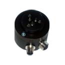
A height reference system with base/rover functionality. The base unit is placed at a known elevation, and the rover is mounted on top of the drill rig’s feed beam. The rover calculates its height relative to the base. Correction data is transmitted from the base to the rover via radio modem. The base unit has two batteries with hot-swap functionality and a 12 VDC input via a connector. It can be mounted on a tripod or placed at a fixed location such as a building with a continuous 12 VDC power supply.


Specification
Base
| Supply voltage: | 12VDC battery or 230VDC adapter |
| Power supply: | 100mA |
| Radio modem range: | >100m |
| Survey-in time: | 5 min |
| Working time on two batteries: | Approx. 5 work days |
| Mechanical data: | |
| Housing: | Aluminum anodized |
| Mounting: | 5/8 UNC, standard survey eq. |
| Connections: | |
| External power/USB: | Standard M12 A-code plug, 8 pin Male |
| Radio antenna: | BNC |
| Operating temp.: | -30 – +70°C |
| Storage temp.: | -40 – +85°C |
| Protection: | IP67 |
Rover
| Supply voltage: | 10 – 30 VDC |
| Power supply: | <100mA |
| Bus Connection: | CAN-Open |
| Height accuracy: | < 3cm |
| Mechanical data: | |
| Housing: | Aluminum anodized |
| Mounting: | 5/8 UNC, standard survey eq. |
| Connections: | |
| CAN-bus: | Standard M12 A-code plug, 5 pin Female Internal termination |
| Radio antenna: | BNC |
| Operating temp.: | -30 – +70°C |
| Storage temp.: | -40 – +85°C |
| Protection: | IP67 |
Files
Features


Usage
All GNSS products

GNSS Level / Elevation System
An elevation reference system with base/rover functionality. The base unit is placed at a known height, and the rover is mounted at the top of the feed on the drilling rig.
Explore product

GNSS / GPS Compass
The GNSS compass uses satellites to determine the direction of the drilling rig with high accuracy. It replaces the sight on the CMI Bench instrument.
Explore product
Do you have a question for us?
Reach out to one of our experts and get the answers you need.