
 Request a quote


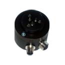
GNSS / GPS Compass
The GNSS compass uses satellites to determine the direction of the drill rig with high accuracy.
It replaces the sight on the CMI Bench instrument. The GNSS compass improves drilling quality by ensuring that all holes are parallel and aligned in the correct drilling direction, eliminating directional errors caused by poor visibility, darkness, or operator mistakes.


Specification
| Data interface: | CANbus with CANopen protocol |
| Accuracy: | Less than 0.5° |
| Power supply: | 24 VDC, 0.2 A |
| Operating temperature: | -30° to +50°C |
Features


All GNSS products

GNSS Level / Elevation System
An elevation reference system with base/rover functionality. The base unit is placed at a known height, and the rover is mounted at the top of the feed on the drilling rig.
Explore product

GNSS / GPS Compass
The GNSS compass uses satellites to determine the direction of the drilling rig with high accuracy. It replaces the sight on the CMI Bench instrument.
Explore product
Do you have a question for us?
Reach out to one of our experts and get the answers you need.